2025 Australian Snow Season Outlook – The Grasshopper’s May Update
Mountainwatch | The Grasshopper
Welcome back to our Australian Seasonal Outlook series for 2025 and with some light snowfall already observed across alpine areas and colder days, it is getting closer to showtime.
In the short term a high-pressure system will roll through over the coming weekend and into next week, with cool southerly winds and the chance of a few snow showers on Saturday/Sunday with 5+cms possible. The colder temperatures across the alpine areas will hopefully allow the resorts to to fire up the snowguns and help establish and early-season base.
As for the season outlook, you might remember from our initial look into the crystal ball for this season it looks likely we’ll have a warmer than average season with hints of a late season resurgence thanks to the possibility of increased moisture. A month on let’s explore if there have been any further developments.

Climate Driver Update
The consensus is that over the next few months El Nino Southern Oscillation (ENSO) will remain neutral until at least the until end of the winter. However, it is important to remember that when looking that far ahead at this time of year can be notoriously hard to predict, a phenomenon known as the spring predictability barrier. Overall ENSO doesn’t look to be specifically influential for the snow season.
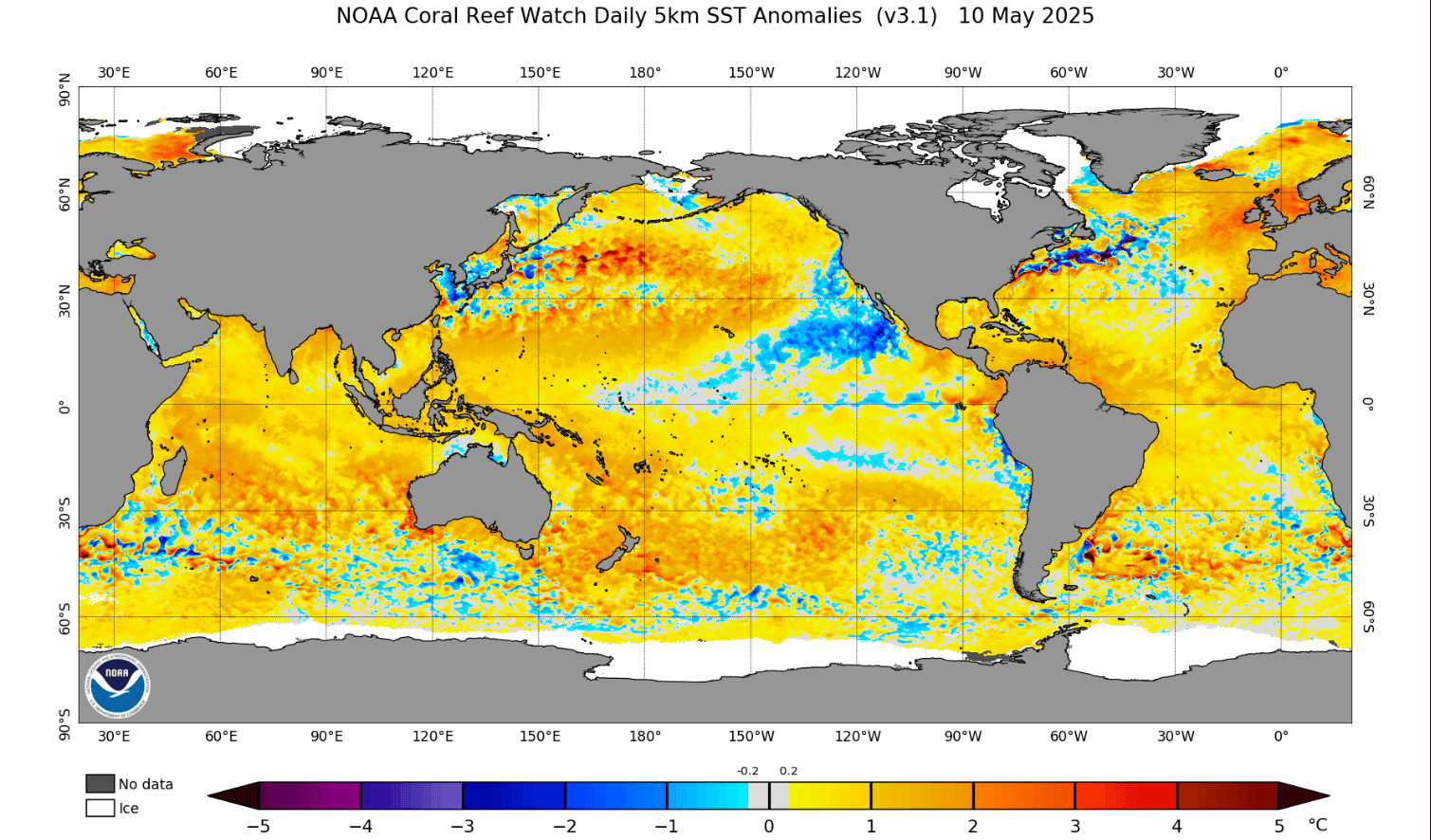
Below we have a seasonal forecast staple, the global SST anomaly. Notable features include neutral values throughout the equatorial Pacific but also predominantly warmer than normal waters surrounding Australia. It was the same last month and is a hint into one of the factors that might help contribute to the forecasted warmer than normal temperatures over the next few months.
So, with no real change with regards to ENSO how about the Indian Ocean Dipole (IOD) ? Last month the story was that the IOD currently being positive would transition to neutral throughout winter. But there were indications of a negative IOD developing during the tail end of the coming snow season.
Below is a visual representation of this situation with different ensemble members from many of the major meteorology players around the world. It shows the negative trend heading further into the second half of the year, but there is also a variance between different ensemble members and agencies. However, there are good signs of the IOD swinging negative with the trend becoming stronger compared to last month’s long-term forecast.
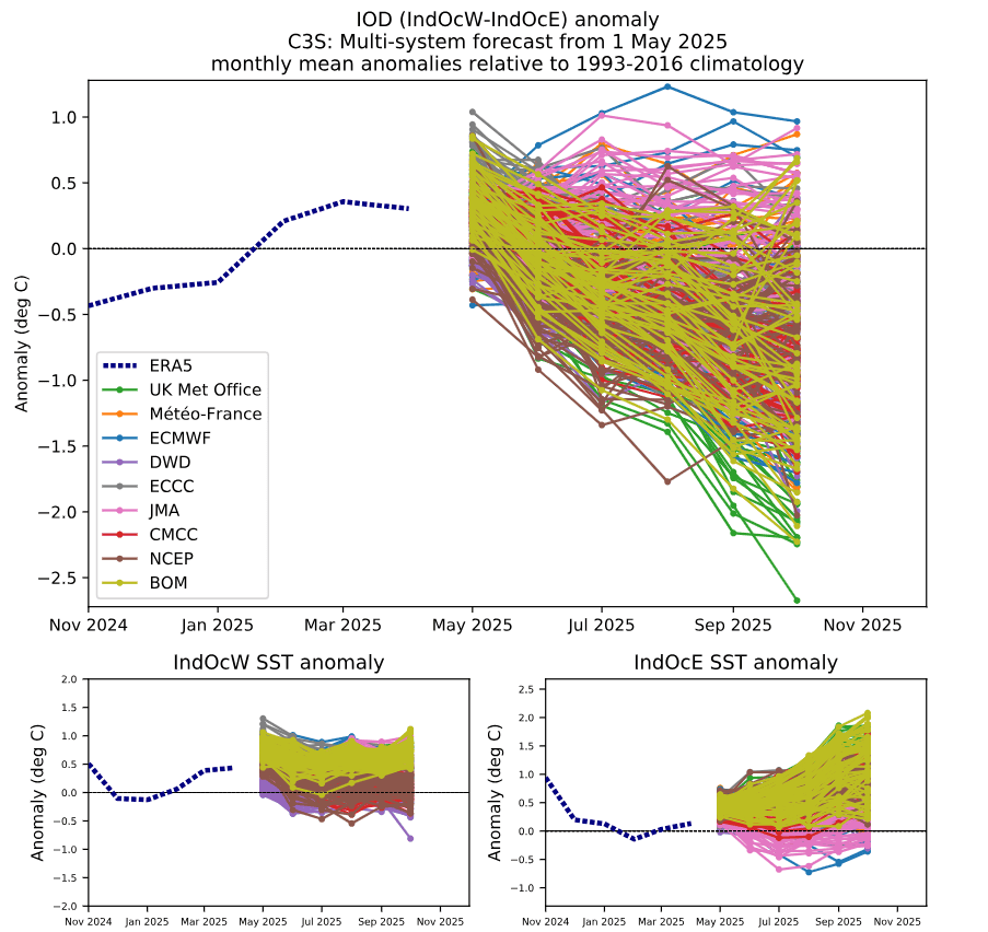
As discussed in our last update, a negative IOD event is typically good news for the snow season as it is categorised by the collection of warmer waters to the northwest of the continent. That provides more moisture available to be transported down to the mid-latitudes and adding some extra juice to snow-bearing systems.
Long Term Product Updates
Looking at the long-term products from the BOM, it is again a similar story to our last update. The high probabilities of warmer-than-average temperatures throughout the snow season may pose a risk to bases at low elevations and also the longevity of the snow base in the latter half of season.

Precipitation remains mostly neutral but again the suggestion of an increase into the back end of the season remains. These ideas are shown below in the outlooks for temperature and precipitation, comparing the outlooks for the June-August months and then for July to September.

Again, we are still a little far out to be investigating shorter term drivers such as the Southern Annular Mode (SAM) or the Madden-Julian Oscillation (MJO), but they will come into play heading into the thick of the season. For example when SAM is negative it can kick up some cold polar air to meet some of this wetter than usual moisture. SAM phases occur on roughly fortnightly scales, so it is too early to predict how it will evolve for the rest of the season. Stay tuned for their impact in coming updates.
Conclusion
One month closer to the start of the season we are roughly in the same position we were in last month, with slightly more confidence in the overall picture. As we observed last month, warmer temperatures on average appear a very likely scenario throughout the season. A positive sign could be the introduction of more moisture into snow-bearing systems due to a negative shift in the IOD heading into the back half of the snow season. However, if we see continuous warm temperatures, it may mean the best periods of the season will be short lived and closely aligned to any decent systems going through.
It is all very similar to the 2021 season when we also had a neutral ENSO and IOD and it’s worth going back to read 2021 mid-season outlook to get an idea on what we may see in the first half of this year.
Stay tuned for my detailed short-term forecasts which start in a few weeks and I’ll be back updating the long-term situation next month. That’s it from me folks. If you’ve got a different theory on what’s going to happen this winter, or just want to provide feedback, then please hit me up on Facebook and hit the follow button while you’re at it.