New Zealand Forecast – Settled till Wednesday, Rain & Snow Thursday
Published early Monday, 30th June 2025
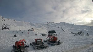
The Southern Lakes scored a solid 25-32cms from Friday night and Saturday’s storm, putting ski fields in a much better position. It was especially timely since it was Opening Weekend at Treble Cone, and when skies cleared up Sunday, you couldn’t have asked for more. There was an extra dusting Sunday night, for which we’re still waiting on morning reports.
Elsewhere, Canterbury copped a lot of rain, but still picked up around 10-15cms. Mt Ruapehu fared worse, with heavy rain and strong winds limiting operations, but somehow the fragile snowpack has made it through.
Monday through Wednesday will bring mostly fine, settled weather as a ridge of high pressure drifts across the country. On Thursday, a low in the Tasman will shove a front over the country, bringing a mix of mainly snow and a bit of rain to the South Island, as well as heavy rain and strong winds to Mt Ruapehu.

Monday 30th June
Chilly west to southwest winds across the country will bring partly sunny, partly cloudy skies to the Southern Lakes. Cloud in Canterbury will clear up this afternoon, while Mt Ruapehu will be cloudy with drizzle at times, although the upper slopes may be clear.
Tuesday 1st June
High pressure pushes in, clearing up any cloud affecting kiwi ski fields during the morning as chilly southwest winds ease over the country.
Wednesday 2nd June
A fine day for ski fields on both Islands, but high cloud gradually increases throughout the day. Light west to northwest breezes for the South Island, while northerly winds pick up over Ruapehu.
Thursday 3rd June
A front from the northwest moves over the country, bringing a mix of rain and snow to the South Island with strengthening northeast winds. The snow will be dense but may fall below base levels for a while. The southern Lakes are likely to receive a dusting of up to about 5cm, while Canterbury could score between 5-15cm if temperatures hold.
It’ll be a grotty day for Mt Ruapehu, with heavy rain and gale-force northerly winds likely limiting operations. Not what they need right now.
Extended Forecast
The Low in the Tasman will weaken significantly as it crosses the North Island on Friday and Saturday, bringing just showers to Mt Ruapehu. Meanwhile, a chilly southerly change could sneak up the South Island on Saturday and give Canterbury ski fields a light dusting of snow, before another ridge of high pressure gives us another settled spell for Sunday and next Monday.
That’s all from me today, folks. I’m sending out these forecasts every Monday, Wednesday and Friday throughout the season. Have a great couple of days, and I’ll see you back here on Wednesday.
Grasshopper