New Zealand Forecast – More Snow For Opening Day on Mt Hutt, Calm and Sunny for the Southern Lakes
Published early Wednesday, 11th June 2024
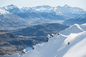
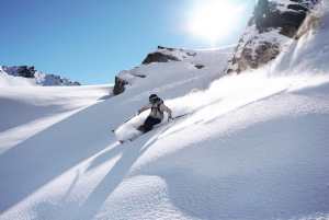
Kia ora te whanau! This coming weekend is Opening Weekend for a lot of major ski fields in Aotearoa, New Zealand, so it’s time to stay glued to the weather forecast. Conditions are great across the South Island after some timely storms in the last several days have brought a tonne of snow and cold temperatures.
Canterbury has scored big-time, with Mt Hutt reporting 97cm of snow falling recently and a snow base of 52-110cm. The Southern Lakes have also had a couple of shots of powder, bringing in around 15-25cm. The groomed runs are particularly looking good, thanks to the snow guns pumping out the good stuff. Reports are yet to come in from a little more snow that fell overnight.
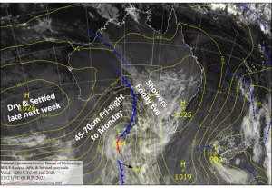
Another storm centred west of the South Island will target Canterbury once again in the coming days, with snow falling Wednesday through Friday. Mt Hutt is well placed to receive one of the highest totals of the region, with 35-60 cm or more up high, but for the most part, temperatures will be marginal on the lower slopes where some of it will fall as rain and sleet.
The Southern Lakes will receive just a skiff of snow late Wednesday and early Thursday, but the snow guns will keep cranking through Opening Weekend, which will be clear and sunny throughout the South Island.

Wednesday 11th June
A partly cloudy day for the Southern Lakes, with light flurries about Treble Cone from afternoon as easterly breezes develop, spreading to the other ski fields at night or overnight.
In Canterbury, light scattered rain will become heavier and more persistent from late afternoon as northwest winds turn east-southeast, while gradually turning to snow down to near base levels. Between 5-15cm could accumulate.
Thursday 12th June
Light snow clears the Southern Lakes in the morning as light easterlies tilt northeast, but flurries may stick around on Treble Cone into the afternoon.
Winds from the east will keep snow falling over Canterbury for much of the day, with heavy falls possible. However, temperatures will be marginal for the lower slopes, with rain and sleet likely for Mt Hutt and nearby ski fields for at least a time. Around 10-25cm is expected to accumulate, but some models have up to 30-45 cm for the upper slopes of Mt Hutt and some other ski fields.
Friday 13th June
The Southern Lakes will remain cloudy for the day as light easterlies drop away. Chilly temps for snow making.
Solid snowfalls in Canterbury during the morning as snow levels drop to base altitudes. The snow will ease throughout the latter half of the day as snow levels continue to fall. Mt Hutt will be favoured on their Opening Day, with up to 15-20cm up high, while other fields are likely to receive 5-15cm.
Saturday 14th June
A perfect, calm, sunny day for Opening Day in the Southern Lakes. Remaining snowfall in Canterbury clears during the wee hours. Clouds will then gradually break up for a nice, calm, sunny end to the day. It’ll also be nice and cold for snow making.
Sunday 15th June
An absolute stunner for the South Island, with calm sunny skies for the first Sunday session of the season. Cold temps morning and night for the snow guns.
Extended Forecast
High pressure will likely keep a lid on the weather over the South Island for most of next week, with a good run of cold temperatures allowing the snow guns to keep the ski fields topped up.
However, northern Canterbury could see decent snowfall on Monday 16th into Tuesday 17th, benefiting Mt Lyford ski fields ahead of their opening day on the 26th June. There is a chance we could also see a mix of rain and snow at some point next weekend, the 21st and 22nd of June.
That’s all from me today, folks. I’m sending out these forecasts every Monday, Wednesday and Friday throughout the season. So, see you back here Friday.
Grasshopper